Topology Errors

13 March 2006

Jumping the Shark--Who's Next?

"Jumping the Shark" is a term for identifying that exact point in time when fans of a show or subscribers to a publication realize (in retrospect) that the show or publication has passed its peak. In a previous post, I identified a printed editorial in GIS Monitor from Feb '05 as a watershed event. Looking back, that editorial is when GIS Monitor "jumped the shark" for me. I unsubscribed around that time and haven't heard much conversation about them in the blogosphere. So I wonder, "Has anyone else jumped the shark? Who's next? Who is on skis skimming across the water with flair? Who is donning their flotation device?"

Note: Even before the comments come in I'll admit to jumping the shark with "Interesting Versus Useful". The good news for me is that I am an "amateur" at this GIS blogging stuff and love my day job. This isn't my first blog and it isn't my last. (But it is the last where I'll use Blogger.)

12 March 2006

Authority - Part 2 (Established Geospatial Press vs. Blogosphere)

Most of the established geospatial press (that which existed before 2005) rose to prominence because they were the independent voice in an arena of competing vendor claims. Examples include Directions Magazine, Geospatial Solutions, GeoWorld, GIS Café, GIS Monitor, and GIS User. In general, their editors lack in-depth knowledge of current technology at the nuts-and-bolts level. Communicating is their full-time "professional" job. In order to write analysis and commentary, they review company pronouncements, read their competitors' analysis, monitor blogs, attend conferences, conduct interviews, and play with geospatial software on their personal computers or small labs.

In contrast, the everyday job of the GIS professional is using current software tools for data acquisition, data automation, maintaining data, creating metadata, making useful maps, distributing maps, conducting geographic analysis, reporting results, training, and keeping the system running when upgrading hardware and software across the organization. They know more about how these tools work in the real world than even the software companies that create them. When GIS professionals enter the blogosphere as an "amateur" communicator and each contribute a few hundred words a week, they carry more authority than the "professional" GIS press and analysts. At some point, the collective group of "amateur" communicators will outweigh the "professional" GIS press and analysts because the "amateurs" are the bona-fide authorities.

So, what is the long-term future of the established geospatial press? They've got an established subscriber base and revenue stream from advertisers. It will be a while before everyone uses RSS aggregators so their immediate prospects are not dim. Software like Google Earth and NASA Worldwind are making more people aware of mapping and GIS so their subscriber base may grow in the near term. As a result, I'm not certain of the long-term future of the established geospatial press. But, I think a lot of people don't care because they already get more timely and knowledgeable information from the blogosphere. It's as simple as adding Planet Geospatial into your RSS aggregator. Thanks again James!
11 March 2006

Authority - Part 1

I finished Naked Conversations and experienced a few epiphanies in the final chapters. The first surrounds the idea that the two most fundamental rules for blogging about a subject are passion and authority. Regarding authority, Shel Israel and Robert Scoble give the example of Bob Lutz's blog on p. 51. Bob is the GM Vice Chairman and author of the Fast Lane blog. So for about 150 pages, I'm thinking that there isn't much opportunity for blogging in the geospatial realm because not many people are in a similar position to Bob Lutz. Yesterday I figured out that authority on a subject doesn't come from a title or position. Rather it comes from insight and understanding. It's the old, "knowledge is power" thing. It's the reason a blog can pop up and gain an instant following such as Drkside of GIS as a recent example. Up to this point, we hadn't heard from a Java programmer who wasn't a geo-geek. OK, so authority in the blogosphere comes from really knowing the subject at both the conceptual level and the nuts-and-bolts level. More about this in future posts. Gotta run, it's the weekend.

07 March 2006

Unprofessional and Undisciplined - December Comment

On Dec 20, Charles Greer added the following comment:
This is a pretty old thread, but then again I feel like I just discovered the GIS blogosphere, and I think you two have hit on some really interesting things here...

I'm in a job where I adminster ESRI products daily, and I find a great deal of tension between established enterprise software, such as databases and web apps, and GIS apps. ESRI seems to have created the flagship desktop product. But they have a great deal of difficulty tackling the idea of the enterprise. In developing enterprise apps, it seems time and again it's the simple solutions, such as Google's circumvention of dynamic vector rendering, that really have the bang for the buck in spatial technology. I think that ESRI's ArcGIS server is woefully too complex a program to really address the really very simple spatial needs of a large business.

I'm able to turn heads daily by leveraging DB2's spatial Extender, and I'm SOOOOO thankful that my employer went the route of getting a real spatial RDBMS. And I cringe whenever I'm forced to jump through all the interface hoops that ArcGIS gives me.

That said, howzabout my website's professionalism? It is tough for intelligent malcontents to buckle down and act professional. I try, but the most rewarding moments are when two people can realize they are able to sit down and go past all that for a while and simply get some interesting stuff done. That said, endless rants are usually boring, and I hope I've not simply thrown one at ya.

Thanks again for the comments. The only reason I moderate comments is to remove spam. Check out the comments at the bottom of Berlin's original post and you'll see what I want to avoid. And just to keep score, Berlins initial attack was 205 words, my rebuttal was 229 words, James White's comment was 262 words, and Charles Greer comment was 255 words. One thing about the blogosphere is there never seems to be the last word. Regarding IBM DB2 Spatial Extender, I remember hearing that it is an OEM version of ESRI's ArcSDE.


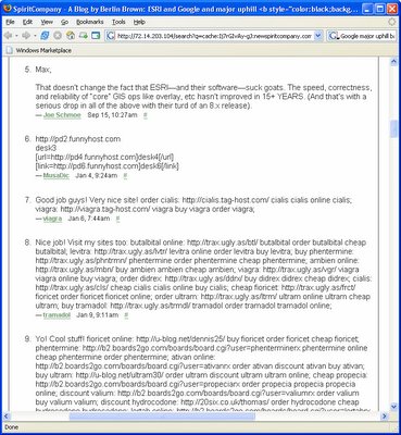
(Update: About five days after my post all comments were removed from Berlin's original post. Thanks to Google cache I can provide a screen capture of where the real comments ended at #5 and the spam comments started at #6. In fact, spam comments went through #51.)

Unprofessional and Undisciplined - November Comment

On Nov 18, James White commented to my Aug 16 post. Since comments on Topology Errors are a bit difficult to scan and read, I've posted the comments here.

Chris, thank you for the opportunity to comment on your site. I find your attack of Berlin Brown to be both unprofessional, and perhaps a bit scary. I am a fisheries scientist. Based on your comments and attack of Mr. Brown, I have decided to call my dad and tell him that he must give up fishing, a hobby that he loves, and that he must never speak about fishing again, ever, because once, in his excitement and ignorance he said he caught a bull trout when it was actually a brown trout. The fact is, our nation is built on a tradition of amateur science. The freedom to explore new topics, and the courage to express untrained opinions, is a trademark of that tradition. Further, for an individual holding an adverse opinion to be labeled as a cranky malcontent, smacks of an awful sort of elitism. Finally, to address your closing statements of the blogosphere having an overabundance of uprofessionals who wear their unprofessionalism as a “badge of courage,” my answer is that “They are people Chris! We call them people. They are people who are interested in things. They are people who have opinions and the courage to display those opinions for the world.” I agree, perhaps, that there has been an explosion in the blogosphere of what can be called nothing other than noise. However, heaven help us if a day comes that the only opinion we can get on a topic, as you seem to suggest with hope, comes from the elite “professionals” in the center. Thank you.

Thanks, James. I appreciate your input. My only comment is that Berlin Brown was the first to sling mud. Everyone who slings mud at a COTS vendor for high prices also hits those who willingly invested the big bucks for enterprise solutions, successfully implemented them, and delivered a great return on investment for their organization.

Hello World, I'm Back

Back in August, I was more than happy to stop posting to the GIS blogosphere and simply lurk. I had made my point and I've got a day job that keeps me occupied full time and then some. Plus, my biggest challenges at work aren't with GIS software technology but with making the right things happen in a large organization. Change management, hiring and training, collaboration, leadership, coaching, keeping business processes up-to-date, scrapping off the barnacles that seem to grow everywhere, developing and documenting a unified vision, etc. are all bigger challenges than deciding between Microsoft MapPoint, Live Local, Google Earth, Google Local, ESRI's ArcGIS Explorer, ArcWeb Services, or Yahoo! Maps. (Yes, that was a blatant use of buzzwords just to get picked up in search terms.) And, I honestly didn't miss my 27 days of blogosphere-supplied dopamine. But time has passed and I have a point of view to add to the cacophony so I'm at the keyboard. I logged into my accounts and found two well-written comments awaiting moderation. They are interesting enough to warrant their own position on the blog so they'll be the first real posts in Topology Errors for 2006.